THE EARLY TOWNSHIPS
OF
BURRA
SOUTH AUSTRALIA
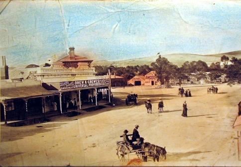
A view of Market Square Kooringa from Commercial Street
c 1900
© The Burra History Group
2007
Kooringa (1845) – A Company Town
The township of Kooringa was the first mining company town in Australia, being set entirely within the mining property of the South Australian Mining Association (SAMA). The town takes its name from an aboriginal name Kuri-ngga, meaning “in the circle.”
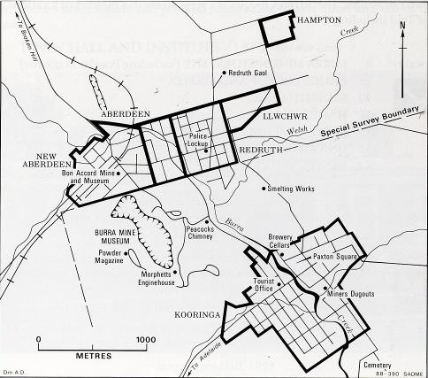
The layout of the township was planned by George Strickland Kingston, a company director, with the intention of building houses for their employees. The first stone cottages, designed by Kingston, were completed in 1846 in Thames Street near the Burra Burra Creek. More than 100 cottages eventually were built by the company, the most notable being the bluestone cottage rows of Paxton Square, but progress on their construction was slow. The first of three rows was built in 1849 with the final row being completed in 1851. Because the company charged rent for these properties and because housing was scarce, the miners resorted to digging their homes into the banks of the creek.
By 1850, these dugouts extended for about two miles along the Burra Creek. It seems that after construction of the cottages, in Thames Street, the company built smaller cottages for miners, presumably at lower rent, in an attempt to entice these “creek dwellers” out of the creek. So the early township grew along the creek from the Mine Bridge down to Mitchell Flat and The Pig and Whistle Hotel (Corner of Thames and Stock Streets).
There were many creek crossings, mostly fords, but there were footbridges at places like The Pig and Whistle Crossing and behind The Miners Arms Hotel, with the only substantial bridge, the Town Bridge, one that could allow a horse and buggy to cross, on Bridge Street. This bridge was financed as follows; SAMA £100, William Paxton, a director of the Mining Company £50 and the remaining £50 by the people of Kooringa. The frequent flooding of the creek often damaged these bridges and the great flood of 1877 swept the Town Bridge completely away.
In the census of 1851 with the mine “in full swing” there were 4000 inhabitants, the largest town in the colony outside of Adelaide. With the
discovery of the Victorian gold fields in 1852, a mass exodus of miners left many houses vacant and falling into disrepair. When the miners returned and mining operations resumed in 1855, the town population grew again, peaking in 1859.
Another exodus of miners and their families came when copper mining at Wallaroo and Moonta commenced in 1861, only to see many return as a result of a strike at the Moonta mines in 1864. Before the closing of the mine in 1877, the township of Kooringa boasted several churches, many hotels, two banks, a ‘public’ school, a Grammar school and the Miners’ and Mechanics’ Institute (now the Town Hall).
The township of Redruth that was surveyed in 1849 grew from a collection of government buildings like the police station (1847) and the courthouse, to become the centre of government activity. It took its name from the name of a town in Cornwall. This name derives from the Cornish ‘ridruth’ meaning red ford.
With no freehold property being available within Kooringa, the Government of the Colony was encouraged to layout a new township to the northeast of the mining property, making freehold title available. The Cornish miners were pleased with it being named Redruth. Freehold title was not made available in Kooringa until the 1870s. It was hoped that here people would build permanent homes. In attempt to profit from this development the S.A. Mining Association bought a considerable number of the allotments offered for sale in this new township, pushing up the prices. Nevertheless this town grew to have three churches, one hotel, and other businesses. Even though some of the streets of this township have Cornish names, it was home to a mix of different ethnic groups with a range of occupations. There are some miners’ cottages, built in the Cornish style, still standing today.
In 1856 the Redruth Gaol was built on the outskirts of this town and later it became a Girls Reformatory.
Named after the Scottish city at the mouth of the River Dee (aber meaning mouth)
In 1849, this township was laid out by Robert A.A. Morehead and Mathew Young, the Scottish owners of the failed Bon Accord Mine in an attempt to recoup their loses with a sale of property. Although no copper was found in the deep shafts that were sunk at the Bon Accord Mine site, water was. This was the source of water that supplied the townships of
Llwchwr (Llwchyr) (1855)
‘Lewsher’, as it is pronounced locally, was named after the town from which the original Welsh smelters migrated in 1849 and 1855. This township came into being through The Patent Copper Co.*, later known as English and Australian Copper Company Ltd., which was the smelter in 1849. With unpronounceable Welsh street names like Penglawdd, Llanelly, Methyr and Llsynwydd, Llwchwr the township was intended for Welsh immigrants who came to work at the smelter. In fact very few people settled here at this time and most of the permanent inhabitants were Germans who had migrated from the Harz Mountains in Hanover. One large Llwchwr residence, built in the late 1840s was the home of Heinrich Christian Wilhelm Fuss, who was in charge of the Smelting Charge yard from 1848 to the 1860s. It was the Welsh and German settlers who had knowledge of the smelting process.
* This company originated in Swansea ,Wales with John Schneider as its director.
Burra for many years. Although this township initially was slow to develop, it became a commercial area with the arrival of the railway and here Sara and Dunstan established a saw mill and timber yards. By the early 1900s it was a self-contained town with its, hotels and shopkeepers clustered around Sara’s Corner. The Burra Railway Station was first known by the locals as the Aberdeen Railway Station.
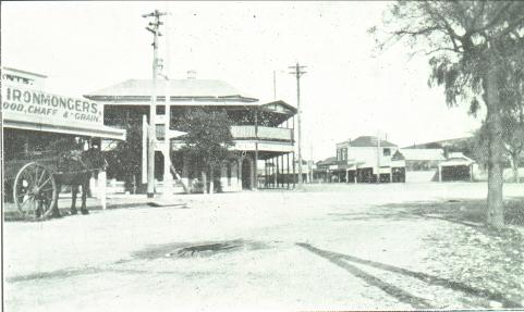
Best Place Aberdeen
New Aberdeen
In 1872, New Aberdeen was added to the west of Taylor Street, Aberdeen. It too was slow to grow, but it became an important part of Burra when the Railway Station was built and later the wheat silos. A flour mill, the Drew and Crewes’ bulk store, the Bon accord Hotel, and the stockyards were all a part of this township. It is also where, much later, the company SAMIN produced copper concentrates from the mine ore.
Copperhouse and Lostwithiel
Copperhouse and Lostwithiel were adjacent subdivisions of section 52 of the Hundred of Kooringa laid out in 1858 west of the Special Survey. Each comprised a single street of houses – about a dozen in each in the 1870s.
Copperhouse, subdivided by William Oliver a hotelier of Redruth, had a Primitive Methodist Church till the amalgamation of the Wesleyan Churches in 1900, a school that closed in 1949 and a hotel from 1864 till 1866.
Lostwithiel was laid out by John Stevens Reed a hotelier of Aberdeen. Lostwithiel, meaning ‘place in the woods’ was named after Reed’s birthplace in Cornwall. It was home to the Race Course Hotel between 1859 and 1896. Both settlements seem generally to have been known as Copperhouse. Now only ruins and a couple of houses remain.
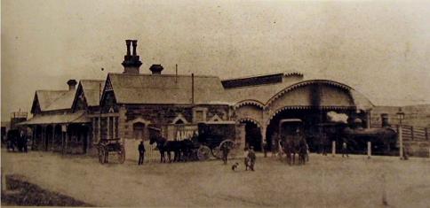
Burra Railway Station New Aberdeen c1900
Established by Thomas William Powell, ‘the Kooringa Postmaster’ in 1857, Hampton, which means ‘hometown’, was named after Powell’s wife’s hometown in Middlesex. Described as an ‘English’ village it grew in size until its ‘hey day’ in 1866 when there were 30 dwellings and a population of 200. It had a store ‘supplying all household requirements’ and its own Bible Christian Church of which there is now little trace. It is the site of three quarries, one of which was in existence before the subdivision of the town that were important in providing stone for the houses and road bridges of Burra. One interesting dwelling was built in one of these quarries and was inhabited until the 1920s.
In 1881 it was described as ‘a less favoured place’, being quite remote from the other townships, with few amenities like water and its inhabitants had to be self-sufficient. There was a well on one property, but the existence of below-ground cisterns indicates that rain water collected from the roofs of houses was the main source of water for this town. By 1891 the population had fallen with houses being abandoned and for the next ten years the number of dwellings remained at around 15.
The people of this town were working class, working in the quarries, building their own homes with this quarry stone and tending gardens enclosed by stonewalls. Some of their occupations were Mine Manager, miller, carpenter, smelter, miner, wheelwright, blacksmith, mason, quarryman, mechanic, labourer and later engine driver, saddler, station
hand, farmer and railway porter.
The Story of The Monster Mine Ian Auhl
The Burra History Group Website www.burrahistory.info/
Burra and Its Townships Lesley Abell
A Less Favoured Place P.J. Birt
Place Names of South Australia G.H. Manning
A Less Favoured Place
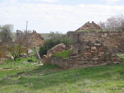
The Ruins of Hampton
2005
Compiled by Julian Ratcliffe
The Burra History Group Incorporated
2007